| View previous topic :: View next topic |
| Author |
Message |
airwave
Joined: 29 Jun 2000
Posts: 386
|
 Posted: Sat May 11, 2013 9:56 am Post subject: Expectations Posted: Sat May 11, 2013 9:56 am Post subject: Expectations |
 |
|
I ended the day yesterday with wind on my mind anticipating a great session today. But this morning while looking at the forecast disappointment set in. Mr Godsey has lowered the forecast.
Why does he keep doing this on the weekends? Why?
Mike, can you please try to arrange for the lulls to happen on Mondays and leave Saturdays alone?
I plan to stand by, in hopes.
|
|
| Back to top |
|
 |
windfind
Joined: 18 Mar 1997
Posts: 1909
|
| Posted: Sat May 11, 2013 10:29 am Post subject: |
|
|
Hi Airwave,
Sorry for the slight forecast downgrade at dawn. Our North Pacific High is being bullied by two massive systems to the west and to the east. And like anyone caught between two bullies its movements are indecisive making forecasting tricky.
Anyway look at the imagery below to get oriented. Then go to this satellite video link:
http://www.atmos.washington.edu/~ovens/wxloop.cgi?wv_common_full+/24h/
Find the storm in the middle of the video then the upper high pressure east of California. Notice that sliver of the North Pacific High's surface NW winds near the California coast? Most of that wind is west of the ocean buoys. The reason that out there is that all the heat induced by the upper high pressure has kept the valley really hot so the valley low pressure has expanded over the coast so the pressure gradient is weak. Later this afternoon that low will shrink so the pressure gradient goes up and the NW wind moves into the Bay. Maybe even stronger than I am forecasting.
Mike
iwindsurf.com
| Description: |
|
| Filesize: |
137.95 KB |
| Viewed: |
13016 Time(s) |

|
Last edited by windfind on Sat May 11, 2013 11:12 am; edited 2 times in total |
|
| Back to top |
|
|
airwave
Joined: 29 Jun 2000
Posts: 386
|
| Posted: Sat May 11, 2013 10:46 am Post subject: |
|
|
This is all your fault !!!
The working wife is particularly disappointed. We pay all this money, to you guys, to be able to go sailing.
If the wind doesn't come around I'll be forced to sit on a racing bike seat.
|
|
| Back to top |
|
|
windward1
Joined: 18 Jun 2000
Posts: 1400
|
| Posted: Sat May 11, 2013 11:06 am Post subject: ???? |
|
|
Hi windfind,
Should not the green arrows on the high be clockwise?
And how does a Valley High drive the Valley Low over to the coast? This I am curious about. How does a High Pressure area sit on top of a Low Pressure area. Is this measured by taking gradients with weather balloons and such? So a medium pressure area as measured at ground level may be made up of a High on top of a Low?
I know so many questions....you will probably tell me to go to meteorological school......
Windward1
|
|
| Back to top |
|
|
churan
Joined: 05 Mar 2008
Posts: 54
|
|
| Back to top |
|
|
windfind
Joined: 18 Mar 1997
Posts: 1909
|
| Posted: Sat May 11, 2013 12:48 pm Post subject: |
|
|
| Quote: | Should not the green arrows on the high be clockwise?
|
Hi Windward1,
Yes, I whipped out that graphic while eating my Cheerios since airwave seemed a little stressed. I have corrected the graphic.
The upper level high pressure east of the Bay Area is at about 18K feet. The descending mass of air from the upper high warms the surface air in the Great Basin and the Central Valley. As this heated surface air expands it creates a low pressure at the surface in the Central Valley. This morning that low pressure area has expanded over Sherman Island so there is only a faint pressure gradient in that area hence the weak winds.
Later today the low pressure pulls back from the coast and cool ocean air flows into the bay pushed by the weak NW wind and sucked by the low pressure in the valley.
The satellite imagery in the link is of water vapor and wind above 10K feet. From that you have to use regular satellite imagery and readings from surface stations, airliners and weather balloons to determine the surface low and high pressures.
|
|
| Back to top |
|
|
rigatoni

Joined: 25 Feb 1999
Posts: 498
|
| Posted: Sat May 11, 2013 1:23 pm Post subject: |
|
|
More importantly, it is always windy on Mothers Day Weekend.
Crissy has been very good the last few days. Ebb is set up nicely for late afternoon.
|
|
| Back to top |
|
|
airwave
Joined: 29 Jun 2000
Posts: 386
|
| Posted: Sat May 11, 2013 2:05 pm Post subject: |
|
|
Hey, Mr Godsey,
We had bagels, eggs, and bacon (turkey flavored cardboard actually).
It just punched up to 21 at T.I. Looking good for some sailing.
Thanks for the reprieve. We are forever in your debt.
|
|
| Back to top |
|
|
airwave
Joined: 29 Jun 2000
Posts: 386
|
| Posted: Sun May 12, 2013 12:02 pm Post subject: |
|
|
Mr. Godsey,
For real, I really appreciate all of your efforts.
From home yesterday the weather was warm, hazy, and dead calm. Without your forecast, not sailing would have been the order of the day. But with it T.I. was in play. As it turned out it was an awesome afternoon of 4.7. Everyone had a great day.
Keep up the good work.
|
|
| Back to top |
|
|
windfind
Joined: 18 Mar 1997
Posts: 1909
|
| Posted: Sun May 12, 2013 12:37 pm Post subject: |
|
|
| Quote: | Mr. Godsey,
For real, I really appreciate all of your efforts. |
Jeez, not even my students at the college called me Mr. Godsey! Just "Mike" will do on good forecast days. On bad forecast days a host of four letter names are available.
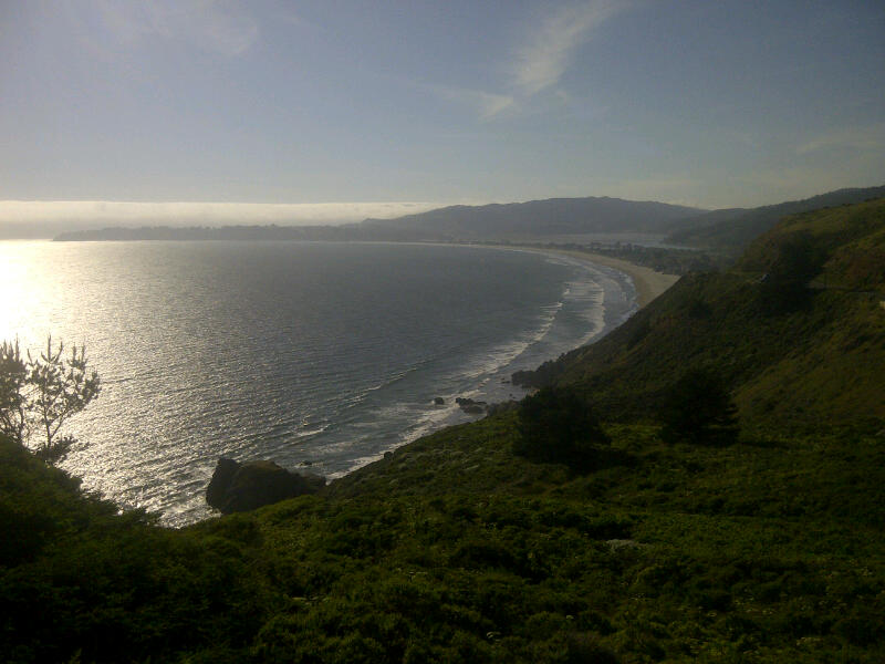
But seriously it is nice for someone to take time to say thanks for our efforts. The Bay Area is one of the toughest yet most beautiful places in the world to try to forecast. Below is one of the many photos I have taken to try to capture the wind scene of the Bay Area.
If you are at Crissy early next week bring some powerful binoculars and looks at the the west side of the very top of the S. tower of the Golden Gate and you may be able to see us doing the most incredible sensor install in history.
Mike
iwindsurf.com
| Description: |
|
| Filesize: |
241.79 KB |
| Viewed: |
12702 Time(s) |

|
|
|
| Back to top |
|
|
|