| View previous topic :: View next topic |
| Author |
Message |
wmike
Joined: 20 Jan 2001
Posts: 207
Location: Maui
|
 Posted: Sun Jun 22, 2014 5:11 pm Post subject: Posted: Sun Jun 22, 2014 5:11 pm Post subject: |
 |
|
| I have been sailing the Wall/Rufus area for some 20 year and find that the Marker 40 data does not help decide if it is worth the trip. I still waste gas going out east that far based on the Maryhill and marker 40 data. Moving Marker 40 to Marker 41 would save me lots of wasted time and gas. Move it.
|
|
| Back to top |
|
 |
scottwerden
Joined: 11 Jul 1999
Posts: 302
|
| Posted: Sun Jun 22, 2014 8:06 pm Post subject: |
|
|
I adjust what the M40 sensor is reporting and don't get skunked all that often at this point. I like to have two points to check for some wind consistency in that corridor, and I am not sure if it matters whether the 2nd point is at M40 or M41. I just want to make sure the wind is sticking to the water from Maryhill all the way into the Wall-Rufus corridor.
I always thought the sensor was out of whack, not that its location was bad.
Anyway, sure go for a new one.
|
|
| Back to top |
|
|
Machu
Joined: 06 Aug 2000
Posts: 15
|
| Posted: Mon Jun 23, 2014 4:10 pm Post subject: |
|
|
| I agree that going to the wall has always been a gamble, and it seems that the existing new location doesn't help with our decision to go or not. The boat launch location is always my sailing location. So it seems that the new location on the north side would give better indication for me.
|
|
| Back to top |
|
|
jimjac
Joined: 26 May 2000
Posts: 1
|
| Posted: Mon Jun 23, 2014 9:22 pm Post subject: |
|
|
| hi mike, while I feel like I have a pretty good handle on the wall, I say please move the site as it should give even better data
|
|
| Back to top |
|
|
shreddbob

Joined: 31 Mar 1987
Posts: 361
Location: Hawaii
|
| Posted: Tue Jun 24, 2014 10:25 pm Post subject: |
|
|
Hi Mike,
Today was decently sailable at the Marker 41 area...but not close to shore by that marker. I checked the wind by the marker many times during 1:45 - 4:30, and it was always light by that island. Even when the wind was better filled in toward the Washington side after 2:30 it still did not go all the way to the Marker 41 island. Of course this was at water level, and I don't know about up on top of an instrument mast on the island. I didn't see the bushes like in your video (bad angle from water?), but the grass did not seem to be moving very much during several passes, when I glanced at it briefly (trying not to fall in with the dying wind).
Today's existing "Wall" sensor at Marker 40 did give a good general idea of the conditions. That said, the correlation with wind quality, where everyone was sailing by Marker 41, was not so accurate. For instance between 1:45 and 2:30 the wind was lightish 4.2 "pump and shred" for me (160 lbs), and mostly only good from the middle over to the Oregon side. From 2:30 - 4:30 the wind was "spanky gusty 4.2" with more downhaul because of the big gusts. You wouldn't know how evil the gusts were from the M40 sensor readings during this period, or how sketchy it was on the Washington side from 1:45 - 2:30.
So I'd say that on a day like today the M40 existing location is better than the proposed M41 location, even though M40 is not perfect.
Hope this is helpful.
Bob
Question: Is WSW better than W here? I have a feeling that while I was driving/rigging 12 - 1:30 was the best wind of the day....but then I usually get that feeling 
| Description: |
|
| Filesize: |
19.8 KB |
| Viewed: |
15077 Time(s) |

|
Last edited by shreddbob on Wed Jun 25, 2014 12:02 am; edited 3 times in total |
|
| Back to top |
|
|
scottwerden
Joined: 11 Jul 1999
Posts: 302
|
| Posted: Tue Jun 24, 2014 11:54 pm Post subject: |
|
|
| Yeah I had the same thought - the wind was not filled in to the N side of the river so a sensor at M41 would likely read low today, maybe 23 MPH. So which is worse, one that reads high or one that reads low?
|
|
| Back to top |
|
|
windfind
Joined: 18 Mar 1997
Posts: 1904
|
| Posted: Wed Jun 25, 2014 8:53 am Post subject: |
|
|
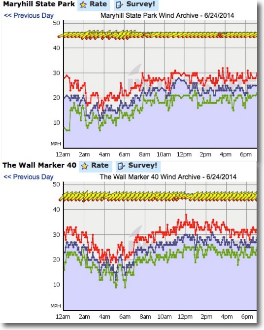
Hi Scott & Shreddbob,
Thanks for the reports and thoughts. If you compare yesterdays Maryhill and The Wall M 40 wind graphs below you can see they are almost identical except that the Maryhill sensor reads a few knots higher since is higher up next to a grain elevator.
On really strong days both the Maryhill and the M40 sensors are useful for estimating the The Wall wind once you get the velocity and direction correction factor. But having 2 sensors close to each other that give basically the same information does not make sense. Especially since neither is really at The Wall and are far from Rufus.
The issue is that there are windy days when you get the same readings you see in the wind graphs below and the winds are so light on the WA side you can not launch since all the wind is on the Oregon side. So people make the long drive only to get skunked.
So the idea of moving the sensor to the island is this:
1. You use the Maryhill sensor to see if the wind is strong enough to make for good swell and sailing mid river. Often times when this sensor reaches 27 knots or stronger there will be sailable wind at The Wall at least on the OR. side.
2. Then you use the proposed M41 island sensor at the launch site to see if the wind reaching the WA side is strong and steady enough to launch.
So if you saw 32 knots at Maryhill but only 11 at the island launch site....you might take a pass.
But if you saw 28 at Maryhill and 19 at the island you could consider going.
So the issue I need your feedback on is not about whether the existing Wall sensor is useful. (Since it clearly is useful but just redundant of the Maryhill sensor.)
The question is...... would it would be better to have one sensor on the Or. side and one on the WA. side at the launch site.
Mike Godsey
| Description: |
|
| Filesize: |
99.33 KB |
| Viewed: |
15028 Time(s) |
|
|
|
| Back to top |
|
|
Larry.Lampshade
Joined: 10 Apr 2000
Posts: 23
|
| Posted: Wed Jun 25, 2014 9:05 am Post subject: |
|
|
Why not keep the sensor at "M40", add a new one at the proposed new location and take the average of the wind speeds from both. The new location will read low for that rock is often in a slight wind shadow whereas the current M40 reads high for it is almost always windier on that side of the river.
Or if averaging is not desirable adding a third sensor would be helpful for then others can do their own triangulation on the wind before making the drive.
Just a thought.
Whatever you decide, thank you for the service you provide - you have saved me many a gallon of gas over the years!
|
|
| Back to top |
|
|
scottwerden
Joined: 11 Jul 1999
Posts: 302
|
| Posted: Wed Jun 25, 2014 1:12 pm Post subject: |
|
|
I am not so sure just having M41 + Maryhill is sufficient. If I see M41 ~ 20, I won't know if the wind is uniform but light at the Wall, or if it is just not filled-in to the N side. I never drive now if M40 ~20, even if Maryhill is 30. I think you have to keep M40.
If we can have both M40 and M41, that would be great. My cell phone scrolls, it can read as many sensors as you put up! 
|
|
| Back to top |
|
|
shreddbob
Joined: 31 Mar 1987
Posts: 361
Location: Hawaii
|
| Posted: Wed Jun 25, 2014 2:44 pm Post subject: |
|
|
Some data from the M41 island would sure help here. If it's not feasible to have 3 permanent sensors in this corridor, what about some kind of data trial for an M41 sensor?
One possible idea? Put in a stripped down wind station here, that records over a few weeks, but not necessarily with networking to the system. At the end of the few weeks the data would be retrieved, and compared to the other 2 sensors. During this trial, wind users would be encouraged to keep notes on their sailing sessions.
|
|
| Back to top |
|
|
|
|
You cannot post new topics in this forum
You cannot reply to topics in this forum
You cannot edit your posts in this forum
You cannot delete your posts in this forum
You cannot vote in polls in this forum
You can attach files in this forum
You can download files in this forum
|
|
|

