| View previous topic :: View next topic |
| Author |
Message |
windfind
Joined: 18 Mar 1997
Posts: 1901
|
 Posted: Mon Jul 09, 2018 10:40 am Post subject: Yet another "Mega Eddy" arrives... Posted: Mon Jul 09, 2018 10:40 am Post subject: Yet another "Mega Eddy" arrives... |
 |
|
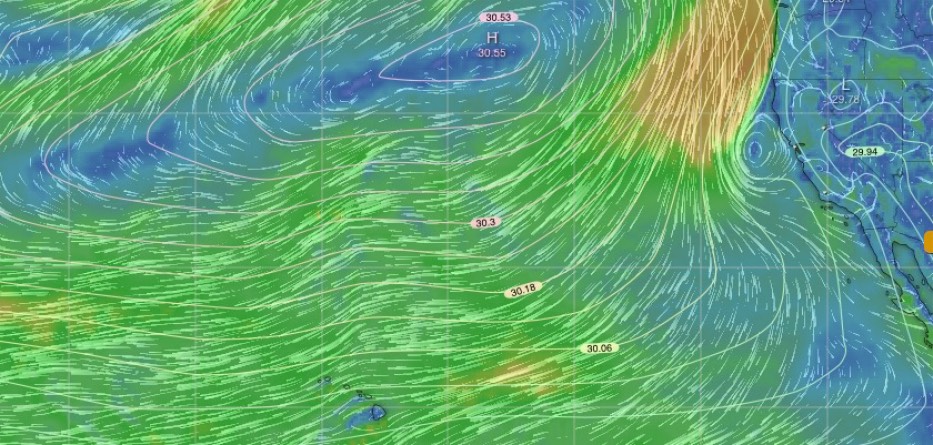
Hi Gang,
Here is my guesscast for Wednesday through Sunday
Starting Tuesday evening or Wednesday AM the North Pacific High extends a lobe from its Pacific home into Northern California just north of Sonoma to the Pacific Northwest. This turns the North Pacific High's surface winds NNW and encourages surface low pressure develops in the Chico to coast region north of the Bay Area. This means we have a S. to N. pressure gradient. All of this works to spin up a 20 mile wide Golden Gate eddy creating weak southerly flow along the coast and into the Bay. And then the pressure gradient towards Chico accelerates this wind.
Then Wednesday a counter-clockwise spinning low pressure develops from just aloft to over 10,000 feet. This cause the 30 mile wide Golden Gate Eddy to balloon to a 100-mile wide eddy by nightfall and to a 300-mile wide eddy/low pressure by Thursday. All the while throwing southerly winds at the Bay Area.
This critter moves further offshore Saturday and Sunday and the ocean winds slowly turn more westerly. All the while a 4000 mile wide North Pacific High spins merrily with strong NW winds several hundred miles to our west. And, Hawaii enjoys strong trade winds from the North Pacific High as you can see in the image below.
Mike Godsey
iwindsurf.com/ikitesurf.com
Weatheflow.com
| Description: |
|
| Filesize: |
161.51 KB |
| Viewed: |
19935 Time(s) |
|
|
|
| Back to top |
|
 |
ethurlow
Joined: 07 Dec 2002
Posts: 119
|
| Posted: Mon Jul 09, 2018 1:33 pm Post subject: |
|
|
Hi Mike, Interesting wind patterns this year. It seems like a lot more W/WSW in bay, WNW at Sherman, and NW at Coast, more like an August but with higher wind speeds.
Thanks for Forecasts.
I think Waddell sensor is reading a bit low lately (maybe wind direction dependence issue too), great wind yesterdsy at about 25mph.
Ernie
|
|
| Back to top |
|
|
feuser
Joined: 29 Oct 2002
Posts: 1508
|
|
| Back to top |
|
|
rowena

Joined: 13 Aug 2003
Posts: 168
Location: Mars satellite
|
| Posted: Wed Jul 11, 2018 6:08 pm Post subject: Leo Carrillo |
|
|
Hi Mike,
Since the Leo Carrillo wind sensor has been down for a year, could you tell us your best guess on what's happening with wind in So Cal? Leo Carrillo isn't Ventura, so we are just guessing. Monsoonal moisture probably affecting us until tomorrow. Looks good for weekend. Your expert thoughts? Thanks!
|
|
| Back to top |
|
|
windfind
Joined: 18 Mar 1997
Posts: 1901
|
| Posted: Wed Jul 11, 2018 7:16 pm Post subject: |
|
|
| Quote: | Hi Mike, Interesting wind patterns this year. It seems like a lot more W/WSW in bay, WNW at Sherman, and NW at Coast, more like an August but with higher wind speeds.
Thanks for Forecasts.
I think Waddell sensor is reading a bit low lately (maybe wind direction dependence issue too), great wind yesterdsy at about 25mph.
Ernie |
Hi Ernie,
Really great observations. Hard to believe but every one of your observations has the same root cause. ie. The North Pacific High has been located further south than normal the last month. Hence Waddell consistent wind anytime there is not an eddy.
And the North Pacific High being so far south means the NPH is more likely to shove a lobe into far Northern California which creates eddy conditions and more WSW to SW winds inside the Bay.
And this also contributes to the "mega eddy" which makes WNW to NW winds at Sherman Island since the pressure gradient is more to Stockton and less to Sacramento.
And when the NPH pushes a lobe into far Northern California the winds aloft turn NNW to NNE on the bluff behind Waddell. This wind tries to push the NW wind away from the sensor so it may read low. Sometimes it even pushes the NW winds away from shore so you can see white caps outside but weaker winds inside at Waddell.
Mike
Hi rowena,
Ben flew into Southern California a few days ago and spent the time trying to arrange a new sensor site for Leo. For various reasons is tough place to get a sensor right on the coast.
The huge eddy due west of San Francisco begins to break up Friday. That will allow the North Pacific High's surface NW winds to build over the Southern California Bight. The inland valleys warm into the 90's Saturday and there is a bit of a pressure gradient to the deserts. This is a good set up for the Long Beach and somewhat promising for Leo. Really too far out to be more specific.
Mike
Last edited by windfind on Wed Jul 11, 2018 7:31 pm; edited 1 time in total |
|
| Back to top |
|
|
rowena
Joined: 13 Aug 2003
Posts: 168
Location: Mars satellite
|
| Posted: Wed Jul 11, 2018 7:22 pm Post subject: |
|
|
| Thanks, Mike!
|
|
| Back to top |
|
|
|
|
You cannot post new topics in this forum
You cannot reply to topics in this forum
You cannot edit your posts in this forum
You cannot delete your posts in this forum
You cannot vote in polls in this forum
You can attach files in this forum
You can download files in this forum
|
|
|

