| View previous topic :: View next topic |
| Author |
Message |
loopless
Joined: 30 Jun 1997
Posts: 426
|
 Posted: Sat Jul 06, 2019 3:02 pm Post subject: New GFS to improve forecasts? Posted: Sat Jul 06, 2019 3:02 pm Post subject: New GFS to improve forecasts? |
 |
|
| Is the new GFS FV3 forecasting model going to improve our wind forecasts?
|
|
| Back to top |
|
 |
windfind
Joined: 18 Mar 1997
Posts: 1901
|
| Posted: Sat Jul 06, 2019 4:08 pm Post subject: Re: New GFS to improve forecasts? |
|
|
| loopless wrote: | | Is the new GFS FV3 forecasting model going to improve our wind forecasts? |
Hi loopless,
Short answer... no.
Why:
The new GFS FV3 models is based upon the same physics as the current GFS. The difference are noted below.
The new GFS will be as good or better than the current ECMWF or European model for forecasting the large scale variables behind our winds like the North Pacific High, marine layer depth, approaching upper trough etc.
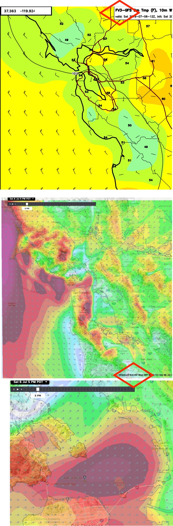
However, to forecast the actual winds at a launch site it is critical for the model to be able to resolve the local topography, heat, vegetation, concentration of buildings etc. The new GFS FV3 has a resolution of 13 km. That means it treats everything inside each 13 km area as having the same elevation etc.
This works great for the ocean or places like the Central Valley but means a poor wind forecast for areas like the Bay Area where the topography can go from sea level to the slopes of Mt. Tam within 13 km. ie. the model does not see the San Bruno, Hwy. 92 or Golden Gate gaps that funnel and accelerate our wind.
Take a look below at the output today at 12Z from our Weatherflow WRF 1 km. resolution and the same time for the GFS FV3 13 km resolution. Huge difference, huh?
Why can Weatherflow afford to run a model at a higher resolution than the feds? It is simple, we run the model at 1 km for a tiny part of California while the feds are covering the entire world. And even that tiny area we run the WF-WRF is a major ongoing expense for us with several full-time modeling experts and large expenses for Amazon cloud computing.
The good news is that the GFS FV3 has the potential of going to 1 km resolution. But even then it will not rival our WRF since we have hand coded corrections into our version of the WRF to correct for details in the Bay Area topography. And our Denver model ops office is busy working on machine learning capablities for our WRF which will lead to better wind forecasts.
But the real key to better forecasts would be:
1. resolution higher than 1 km. During the America's Cup one of the major competitors paid us to run the WRF at 250 meter resolution. How good were the results? Let's just say it this way... they won the America's Cup and some of the key decisions about course where not race paths one would normally consider. If I had the deep pockets of that company we would run the Bay Area WRF at 1 meter res. and would carry just one sail or kite to the beach each day.
2. More customers sending in their obs. and local knowledge so we could use it in improving the human forecasts and ultimately incorporate it into our machine learning projects. But personally, after a day on the water, I find it easier to whine about a forecast than to send in my observations.
Mike Godsey
iwindsurf.com/ikitesurf.com
Weatheflow.com
Details:
The proposed GFS version uses the same physics package as the current operational GFS except for:
Replacing Zhao-Carr microphysics with the more advanced GFDL microphysics
Updating parameterization of ozone photochemistry with additional production and loss terms
Introducing parameterization of middle atmospheric water vapor photochemistry
Revising bare soil evaporation scheme
The data assimilation system will be updated to include:
Infrared Atmospheric Sounding Interferometer (IASI) moisture channels
Advanced Technology Microwave Sounder (ATMS) all-sky radiances
Fix for an issue with the Near Sea Surface Temperature (NSST) in the Florida Strait
Upgrade to the use of Cross-track Infrared Sounder (CrIS) radiances
NOAA-20 CrIS and ATMS data
Megha-Tropiques SAPHIR data
Advanced Scatterometer (ASCAT) data from MetOp-B
| Description: |
|
| Filesize: |
322.66 KB |
| Viewed: |
15513 Time(s) |
|
|
|
| Back to top |
|
|
loopless
Joined: 30 Jun 1997
Posts: 426
|
| Posted: Mon Jul 08, 2019 9:23 pm Post subject: |
|
|
| Thanks for the informative reply...! All about available computing power. Maybe some bitcoin miners could be convinced to take up windsurfing....
|
|
| Back to top |
|
|
|
|
You cannot post new topics in this forum
You cannot reply to topics in this forum
You cannot edit your posts in this forum
You cannot delete your posts in this forum
You cannot vote in polls in this forum
You can attach files in this forum
You can download files in this forum
|
|
|

