| View previous topic :: View next topic |
| Author |
Message |
windfind
Joined: 18 Mar 1997
Posts: 1901
|
 Posted: Thu Jun 19, 2014 2:47 pm Post subject: Need MORE input: Moving Wall sensor to island launch site? Posted: Thu Jun 19, 2014 2:47 pm Post subject: Need MORE input: Moving Wall sensor to island launch site? |
 |
|
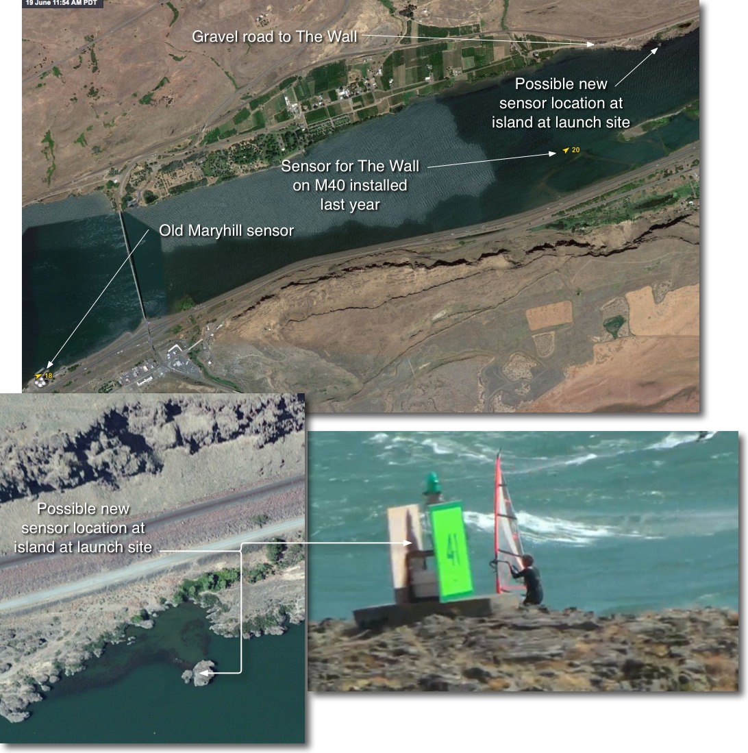
Gang,
This is your chance to get a sensor where YOU want it in the Wall area! Give us our thoughts. A simple YES or NO on the island launch site M41 will suffice!
I have heard a lot of complaints about the Wall sensor installed last year on the Marker 40 Nav. Aid west of The Wall.. This sensor is located out in the river off the Oregon side just west of the last of the narrow islands that parallel 84. If you take the Stonehedge road to The Wall you can see this sensor out in the river as you drive down the hill.
The complaints I have heard about this sensor are:
1. it just replicates the old Maryhill sensor and reads high like that one.
2. It reads SW too often and is slower to shows shift from SW to WSW compared to the Maryhill sensor (probably due to some effect from the nearby bluff)
3. It can show strong wind in the upper 20s but when you get the launch sites, especially the boat ramp launch, the winds are much lighter and or the wind is mostly on the OR side.
It seems to me that M40 is, with corr. factors, useful for epic winds. But on weaker days with low to mid 20s wind the new sensor is almost useless especially at the boat ramp launch sites.
So I would like your thoughts about moving the M40 sensor to the tiny rock island on the Washington side of The Wall at the second major launch site at Marker 41. You can see this location as well as the old Maryhill and newer m40 sensor location in the images below.
I realize that the wind at the rock island, even on a 10 foot mast, will be weaker than mid river but from my limited experience around the island a sensor here would be more useful than M41 since:
1. It is right at the launch site so even if it reads low we could all learn the correction factor fast.
2. It would tell us if the wind was filled in to the WA side. i.e.. if we saw 27 at Maryhill but 10 at the island then we would not start the drive. But if we saw 27 at Maryhill and 19 at the island we could be pretty sure there was solid wind mid river.
3. It would tell us if the wind was too SW to NW right at the launch site.
My biggest concern is that the wind on the island would be too weak to be useful. When you swim around the island to water start if is often dead calm at the water surface due to the rocks just upwind.
However I have been looking at all the video footage I have of The Wall and I can see very strong wind on top of the island and it would be even stronger up on a mast.
Fast forward this video fast to 1:40, 2:07, 3:12, 3:40 and especially 5:25 to see the island getting blasted: http://windnotes.phanfare.com/4743675_5825871
We can only have 2 sensors in The Wall area and everyone is used to using Maryhill so it stays. But before I suggest out moving the M40 sensor to the island I need the input of people who have launched or jibed right at the island for many years.
Thanks,
Mike Godsey
iwindsurf.com
| Description: |
|
| Filesize: |
312.13 KB |
| Viewed: |
23330 Time(s) |
|
Last edited by windfind on Sat Jun 21, 2014 7:46 pm; edited 4 times in total |
|
| Back to top |
|
 |
sissybar
Joined: 29 Apr 2006
Posts: 53
|
| Posted: Thu Jun 19, 2014 2:56 pm Post subject: |
|
|
Off-topic: where is the Rufus gauge? Staggering maryhill, wall, rufus on opposite sides of river might help.
EDIT: I wasn't advocating for a new Rufus wind meter (but that would be good, too) I was asking where the meter is located that is a "nowcast" experimental unit. Is there actually some type of wind gauge at Rufus and where is it? I notice if it blows over 27 from westish direction it is usually good if the Wall is also looking near 30.
The wind is very fickle in that stretch of river and it can be howling at the Biggs Silos and near glass at Rufus. More info the merrier on both sides of river to deal with nw to ssw.
Last edited by sissybar on Thu Jun 19, 2014 6:42 pm; edited 1 time in total |
|
| Back to top |
|
|
ldhr
Joined: 10 Apr 2000
Posts: 121
|
| Posted: Thu Jun 19, 2014 3:47 pm Post subject: |
|
|
i vote Rufus.
with one at Maryhill and another at Rufus - it should be easy to guess what the conditions at the Wall will be.
also - most days the majority of sailors are kiters at Rufus, not windsurfers at the wall.
guessing your customers are evenly divided so a sensor at Rufus would be most usefull to the kite customers.
|
|
| Back to top |
|
|
roxanne
Joined: 14 Jun 2011
Posts: 3
|
| Posted: Thu Jun 19, 2014 9:41 pm Post subject: |
|
|
| I think that would be worth trying. We always sail from that launch and when the wind direction is right it is definitely filled in right to the island; so I think it would provide useful data.
|
|
| Back to top |
|
|
doug_needs_wind
Joined: 02 May 2005
Posts: 35
|
| Posted: Thu Jun 19, 2014 10:51 pm Post subject: |
|
|
| I vote for the small island! We need data on both sides of the river. Dead on the island means a mostly dead river.
|
|
| Back to top |
|
|
windfind
Joined: 18 Mar 1997
Posts: 1901
|
| Posted: Fri Jun 20, 2014 9:37 am Post subject: |
|
|
| Quote: | | Sissybar said: "I was asking where the meter is located that is a "nowcast" experimental unit. Is there actually some type of wind gauge at Rufus and where is it?" |
Hi Sissybar,
The "nowcast" readings you can see in windalert.com are not experimental sensors. All they are is an indication of what one of the models says the wind "should" be at that location and time. In some parts of the country where there is little or no topography "nowcast" readings are useful for customers living where there are no sensors. But in the Gorge the Rufus "nowcast" is likely to be somewhat accurate only if the actual wind is flowing straight down the river.
The narrow steep walls Maryhill to Biggs part of the Gorge makes the area extremely sensitive to wind direction. That is why we are looking to move the sensor to a better location.
The biggest issue is that on days when the wind are a bit more SW the 2 current sensors can be reading in the upper 20's but most of the wind is on the Oregon side and at Rufus. So people make the long drive to the Wall to find they can not sail.
Mike Godsey
iwindsurf.com[/quote]
|
|
| Back to top |
|
|
30knotwind
Joined: 30 Aug 2005
Posts: 239
Location: White Salmon, WA
|
| Posted: Fri Jun 20, 2014 12:09 pm Post subject: |
|
|
Averages
~30 mph at The Hatchery: I sail a 2.9
~30 mph at The Wall: I sail between a 4.7 to 5.5
(I don't go out here now unless avg wind is firmly above 30 with big gusts)
~30 mph at Loroc Island: I sail a 4.2
(I'm 190 lb)
I've heard that the Hatch air is 'heavier' so that may make a difference, but local knowledge means everything when interpreting the sensor readings. Anything iW can do to improve the data would be interesting, e.g. moving sensors or a 1-10 'sail size' index that accounts for 'heavy' air, gusts etc.
_________________
~~~~~~~~~~~~~~~~~~~~~
http://www.30knotwind.com/ |
|
| Back to top |
|
|
brettn
Joined: 22 Nov 2000
Posts: 114
|
| Posted: Sat Jun 21, 2014 12:12 pm Post subject: |
|
|
A sensor on the north side of the river would be a Godsey send.
Many a time I've seen 25+ on the sensor and hustled east 50 miles, only to sit in the car and do lot of deferred maintenance on my nostrils.
Or get a sesh at Biggs, windsurfing's methadone.
|
|
| Back to top |
|
|
uwindsurf

Joined: 18 Aug 2012
Posts: 968
Location: Classified
|
| Posted: Sun Jun 22, 2014 10:34 am Post subject: |
|
|
Move the sensor to the island. Like many others, I do not drive to the Wall unless the Maryhill sensor is averaging 30 and the direction is SW.
It would be nice to have another data point to add to the decision matrix.
Thanks for all you do Mike.
|
|
| Back to top |
|
|
windaveski
Joined: 17 Nov 1999
Posts: 9
|
| Posted: Sun Jun 22, 2014 11:08 am Post subject: |
|
|
My observations are:
Most of the time the wall sensor reads below the maryhill sensor but when the wall is good (as much of last week) it actually reads above maryhill. I think this may be related to direction but not sure. This makes the current wall sensor useful. I think the island location might be better but I usually launch at the boat ramp so don't have first hand knowledge of the island.
30mph at swell or the wall I would be on a 3.7. The big difference I see is that at 25mph I would be on a 4.2 at swell but at the wall I would be sitting and waiting. (165lbs) There seems to be a very specific threshold above which the wall gets good.
|
|
| Back to top |
|
|
|
|
You cannot post new topics in this forum
You cannot reply to topics in this forum
You cannot edit your posts in this forum
You cannot delete your posts in this forum
You cannot vote in polls in this forum
You can attach files in this forum
You can download files in this forum
|
|
|

