| View previous topic :: View next topic |
| Author |
Message |
verendia
Joined: 20 Oct 2013
Posts: 5
|
 Posted: Tue Jun 02, 2015 4:13 pm Post subject: Forecasting wind for Piedras Blancas Posted: Tue Jun 02, 2015 4:13 pm Post subject: Forecasting wind for Piedras Blancas |
 |
|
| Planning a trip to Piedras Blancas this weekend. Any tip on how to forecast the wind there. Curious why Iwindsurf don't have a human forecast for Ca central coast. Thanks in advance.
|
|
| Back to top |
|
 |
airwave
Joined: 29 Jun 2000
Posts: 386
|
| Posted: Tue Jun 02, 2015 4:48 pm Post subject: |
|
|
I just got back from 2 weeks at San Simeon and go every year about this time.
The wind models on iWindsurf and the Dashboard models on iWindsurf for mobil are pretty accurate. Look at the gust prediction for Piedras Blancas. They are fairly representative of the conditions at Arroyo Laguna below Piedras Blanca and above San Simeon.
The models will change through the day a bit as needed, which really makes them as accurate as a human forecast that only describes the differences 3 times per day.
I've found that the models are usually a few mph lower than the actual, but close enough to decide what to do. Be sure to use the gust predictions instead of the average.
Swell models work pretty well too.
|
|
| Back to top |
|
|
windfind
Joined: 18 Mar 1997
Posts: 1904
|
| Posted: Tue Jun 02, 2015 5:49 pm Post subject: |
|
|
Hi verendia and airwave,
The models are pretty accurate in spring and early summer along the Central California coast when we are in a NW ocean wind pattern at sites with NO topography upwind.
In that case the HRRR and NAM 5 are the models of choice since they update hourly. At a site has any points nearby upwind the WRAMS is a better choice even though it only updates very 6 hours.
All of these models are much less useful once June Gloom sets in since they cannot follow the fog or how the micro topography impacts the thermal winds that allies with the weak June Gloom NW wind to make useful wind.
And if there is a marine surge the models are often useless.
We have long wanted to do a Central California coast forecast. But we need few more sensors to be able to verify forecast accuracy. Unless you know when you have issued a crappy forecast you cannot learn and slowly improve.
Yes, the human forecasts are only 3X per day but we issue special updates if something really changes between forecasts and typically these are things that the models never even see.
We have a really good lead for a Pismo sensor location and that would help some.
Mike Godsey
iwindsurf.com
|
|
| Back to top |
|
|
bprice
Joined: 21 Oct 2000
Posts: 138
|
| Posted: Tue Jun 02, 2015 7:24 pm Post subject: |
|
|
An upper level low is forecast Friday into Saturday with winds out of the south, drizzle and such. Not a good sign. A little hope on Sunday, but it doesn't look good.
Today however, it was sunny warm with beautiful glassy head high green walls and 5.2 wind around 1:30 followed by 4.7 from 2:45 until 4. Everyone cleared off and 4.2's came out... it got a bit bumpy too. Expect similar tomorrow. Too bad the AWT couldn't be today and tomorrow.
|
|
| Back to top |
|
|
windfind
Joined: 18 Mar 1997
Posts: 1904
|
| Posted: Tue Jun 02, 2015 9:11 pm Post subject: |
|
|
Hi Bprice,
Thanks for the input. The upper level low which evolves into a Cut-Off Low is at about 18,000 feet so its winds are are about 3 miles above Waddell. And the lows winds will be North winds not South wind and don't have any direct impact on Waddell's surface winds.
While the upper low does not have any direct impact on Waddell winds it will increase clouds and has some moisture from Tropical Storm Andres so we could see some wetness.
The forecast surface southerly winds Friday are a result of the low pressure north of the Bay Area.
Below shows the direct cause of the forecast southerly winds. The colored area shows the low pressure. Watch the low pressure dance about north of the Bay Area and the resulting southerly winds.
Watch the time/date bar and don't get confused as the low pressure shrinks and swells in the evening as the Central Valley cools. Instead focus on its location and the ramp up of southerly wind.
Mike Godsey
iwindsurf.com
| Description: |
|
| Filesize: |
1.88 MB |
| Viewed: |
17377 Time(s) |

|
|
|
| Back to top |
|
|
hitech
Joined: 13 Aug 2000
Posts: 81
|
| Posted: Tue Jun 02, 2015 9:59 pm Post subject: |
|
|
For Arroya Laguna, sometimes watching the simple trends are the most predictable. Look for the offshore buoys to be blowing in the solid 20's, ideally from the Bay Area south to Point Conception. I key in on Cape San Martin bouy and want to see it blowing in the high 20's all day and night. Unsually if Cape San Martin is blowing, the wind will come into Piedras Blancas/Arroyo Laguna. It can help if it is warm to hot in Paso Robles to get an extra thermal suck to amp up the wind.
Also, check the central coast marine forecasts and you want small craft advisories offshore and near shore.
If they are predicting a Catalina Eddy in SoCal, it is a good sign that the offshore winds are NW all the way down the coast and Arroyo should go off.
Good luck, I will be down the weekend of the 13th and watching all these trends.
I know these things are not as precise as Windfind but we didn't have him in the 80's and 90's and had to figure it out on our own.
Thank god for Godsey now, we have him to blame when it all goes wrong!
|
|
| Back to top |
|
|
nw30

Joined: 21 Dec 2008
Posts: 6485
Location: The eye of the universe, Cen. Cal. coast
|
| Posted: Tue Jun 02, 2015 11:00 pm Post subject: |
|
|
That's all well and good assuming that the Cape San Martin bouy is giving us some info. but it's been down for over a week, no telling when it's going to be back. We are having to rely on more local info and people.
I'm thinking that the AWT might be another SUP event like it turned out last year, hope not, but, it's looking to be no wind this weekend at A.L. 
|
|
| Back to top |
|
|
windfind
Joined: 18 Mar 1997
Posts: 1904
|
| Posted: Wed Jun 03, 2015 10:45 am Post subject: |
|
|
| hitech wrote: | For Arroya Laguna,
If they are predicting a Catalina Eddy in SoCal, it is a good sign that the offshore winds are NW all the way down the coast and Arroyo should go off.
Thank god for Godsey now, we have him to blame when it all goes wrong! |
Hi hitech,
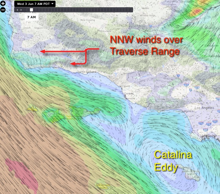
You are right about the Catalina Eddy being a good indicator of Central California beach winds. Here is an additional hint:
The Southern California bight Catalina Eddy is most likely to occur when the North Pacific High's surface winds are a bit more NNW than NW east of Jalama.
Looking at the image below from 8AM this morning to visualize what I am talking about.
You can see this NNW thing on the new iwindsurf.com by zooming in on the mountain area inland of Jalama. For the wind to be NNW over land the ocean winds have to be setting up to come over the beaches.
Mike Godsey
iwindsurf.com
| Description: |
|
| Filesize: |
179.29 KB |
| Viewed: |
17284 Time(s) |
|
|
|
| Back to top |
|
|
hitech
Joined: 13 Aug 2000
Posts: 81
|
| Posted: Wed Jun 03, 2015 10:59 am Post subject: |
|
|
| Good point regarding Cape San Martin body not reporting lately. Mike, what is up with that site? It is my go to for Arroyo Laguna and will need it in about a week!
|
|
| Back to top |
|
|
windfind
Joined: 18 Mar 1997
Posts: 1904
|
| Posted: Wed Jun 03, 2015 12:42 pm Post subject: |
|
|
The Cape San Martin ocean buoy sensor package died on May 18. So the lack of data is not an issue our data stream.
Repairing one of these ocean buoys is quite a project. If a CG ocean buoy tender ship is in the area it could be days before we see a repair. If there is no ship in the area it could be months.
Be aware that these ocean buoys are an endangered species since they are expensive to place and expensive to maintain. Years ago we mounted a customer movement to save the Northern California ocean buoys which was successful. We always have to be prepared to do the same in the future.
Mike
iwindsurf.com
| Description: |
|
| Filesize: |
29.67 KB |
| Viewed: |
17250 Time(s) |

|
|
|
| Back to top |
|
|
|
|
You cannot post new topics in this forum
You cannot reply to topics in this forum
You cannot edit your posts in this forum
You cannot delete your posts in this forum
You cannot vote in polls in this forum
You can attach files in this forum
You can download files in this forum
|
|
|

