| View previous topic :: View next topic |
| Author |
Message |
windfind
Joined: 18 Mar 1997
Posts: 1902
|
 Posted: Tue Nov 17, 2015 10:29 am Post subject: Posted: Tue Nov 17, 2015 10:29 am Post subject: |
 |
|
Hi Gang,
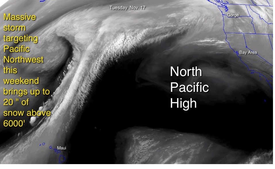
The huge North Pacific High you see in the images above is still dominating the western pacific although its winds are too NNW today to reach the Bay Area.
But as the image below shows a massive storm system targeting Pacific Northwest will bump the NPH far from California as we approach the weekend.
Oh yea, you might ask why can't you see the North Pacific High in satellite imagery? The NPH is created by descending air that came from the ITCZ and as this air descends it compresses and heats which makes clouds unlikely to form anywhere near its center.
Mike Godsey
iwindsurf.com/ikitesurf.com
Weatheflow.com
| Description: |
|
| Filesize: |
111.55 KB |
| Viewed: |
4590 Time(s) |
|
|
|
| Back to top |
|
 |
bajaguy
Joined: 27 Dec 1999
Posts: 69
|
| Posted: Thu Nov 19, 2015 1:57 pm Post subject: |
|
|
Mike, Thanks for the update on the unusual wind pattern. Here in southern Baja, La Ventana is enjoying an epic November. El Norte or not, 16 days in a row and counting. October was pretty light, but November is one to remember.
See you soon, we'll save some wind for ya. (Everyone driving Mx 1 starting tomorrow, drive safe and watch your rear-view mirror, the Baja 1000 starts at 6 am and sections of it are on the highway. Those flashing lights behind you may be a 1000 hp Trophy truck. )
|
|
| Back to top |
|
|
|
|
You cannot post new topics in this forum
You cannot reply to topics in this forum
You cannot edit your posts in this forum
You cannot delete your posts in this forum
You cannot vote in polls in this forum
You can attach files in this forum
You can download files in this forum
|
|
|

