| View previous topic :: View next topic |
| Author |
Message |
windfind
Joined: 18 Mar 1997
Posts: 1901
|
 Posted: Tue Apr 26, 2016 1:41 pm Post subject: Blog: Bay, Gorge, Maui & SoCal rip together! Posted: Tue Apr 26, 2016 1:41 pm Post subject: Blog: Bay, Gorge, Maui & SoCal rip together! |
 |
|
Hi Gang,
As you can see in the imagery below yesterday was a wild day not just for much of the Bay Area but also for the Gorge, Maui & SoCal. Amazingly the causes all this wind were basically the same for all venues.
This blog details these causes in imagery and video:
http://blog.weatherflow.com/3pm-april-25-2016-the-west-rips/
Enjoy,
Mike Godsey
iwindsurf.com/ikitesurf.com
Weatheflow.com
| Description: |
|
| Filesize: |
165.4 KB |
| Viewed: |
14737 Time(s) |

|
|
|
| Back to top |
|
 |
loopless
Joined: 30 Jun 1997
Posts: 426
|
| Posted: Tue Apr 26, 2016 3:21 pm Post subject: |
|
|
| I can tell you PSC was <3.7 on Saturday as well!
|
|
| Back to top |
|
|
airwave
Joined: 29 Jun 2000
Posts: 386
|
| Posted: Tue Apr 26, 2016 4:03 pm Post subject: |
|
|
Mike,
Sunday was a big day as well !
Keep it up !!!
|
|
| Back to top |
|
|
airwave
Joined: 29 Jun 2000
Posts: 386
|
| Posted: Tue Apr 26, 2016 4:10 pm Post subject: |
|
|
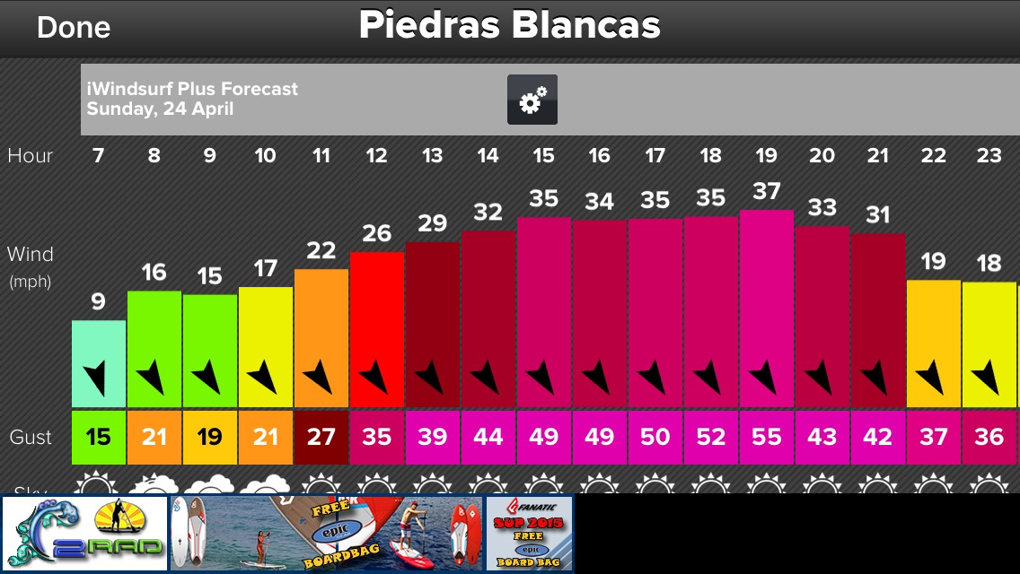
Mike,
I have a question. I am attaching two screen shots. One here. The other on the next post. They are both taken at the same time, on the same day, for the same place. One is from an iPhone. The other from an iPad
Any thoughts on why they are different.
| Description: |
|
| Filesize: |
640.49 KB |
| Viewed: |
14666 Time(s) |

|
Last edited by airwave on Tue Apr 26, 2016 4:38 pm; edited 1 time in total |
|
| Back to top |
|
|
airwave
Joined: 29 Jun 2000
Posts: 386
|
| Posted: Tue Apr 26, 2016 4:38 pm Post subject: |
|
|
Here
| Description: |
|
| Filesize: |
452.64 KB |
| Viewed: |
14638 Time(s) |
|
|
|
| Back to top |
|
|
windfind
Joined: 18 Mar 1997
Posts: 1901
|
| Posted: Tue Apr 26, 2016 5:04 pm Post subject: |
|
|
| loopless wrote: | | I can tell you PSC was <3.7 on Saturday as well! |
Hi Loopless,
Yea I was certain San Carlos was nuking but a graphic that would cover Maui to the Gorge to San Carlos Baja sized to fit on the page would have the text too small to read!
One of the keys to PSC forecasting is the pressure gradient to the Imperial Valley and on to the S. Great Basin. You can see those winds that passed over PSC in the 3rd. graphic,
Hi Airwave,
You are looking at the forecast from to different models. The Quicklook is derived from the low res. NAM 12km and it does not see the compression of wind that happens north of Piedras Blancas and accelerates the wind. Your second image is from our higher resolution WRF model that can better resolve the local topography so it will usually be more accurate.
Remember there are well over a dozen different models with different resolutions and each is better at detecting different factors that impact the wind in different patterns. And sometimes they are all wrong. Not because the physics is wrong but rather because of the limited data input into the models from the pacific.
Mike Godsey
iwindsurf.com/ikitesurf.com
Weatheflow.com
|
|
| Back to top |
|
|
airwave
Joined: 29 Jun 2000
Posts: 386
|
| Posted: Tue Apr 26, 2016 5:13 pm Post subject: |
|
|
Mike,
Thanks for the info.
And you nailed the circumstance. The 2nd graph was indeed the more accurate one.
|
|
| Back to top |
|
|
airwave
Joined: 29 Jun 2000
Posts: 386
|
| Posted: Wed Apr 27, 2016 10:10 am Post subject: |
|
|
Mike,
I thought up a 2nd question.
So, why use a different model for the graph for the iPad then for the iPhone?
|
|
| Back to top |
|
|
windfind
Joined: 18 Mar 1997
Posts: 1901
|
| Posted: Wed Apr 27, 2016 10:50 am Post subject: |
|
|
Hi Airwave,
It could be that you had the settings different or that you checked each device just as a newer model output became available. Also the high rez. models typically only to out 12-36 hours so if you look for time slots beyond that our site defaults to a lower res. model. That is why the model forecast often seems to change from day to day. Never assume that a model forecast more than 1 day out is anything more than a very rough estimate. On the other hand an experienced human forecaster can sometimes make a fairly accurate forecast for wind several days out by recognizing a pattern that is likely to actually pan out.
Mike Godsey
|
|
| Back to top |
|
|
airwave
Joined: 29 Jun 2000
Posts: 386
|
| Posted: Wed Apr 27, 2016 12:02 pm Post subject: |
|
|
Mike,
Thanks for more information.
They both were views at about 7:30AM ish on the morning of day in question. So, both graphs were for current time and forward for the day.
Clearly the iPad was using "Quicklook" and the iPhone was using "iWindsurf Plus Forecast". I now see that on the screen shot.
So, there must be some sort of settings on my two devices that are set up differently. I presume and hope that I can track that down and adjust so they are the same.
In any event it was really windy on Sunday on the Central Coast.
|
|
| Back to top |
|
|
|
|
You cannot post new topics in this forum
You cannot reply to topics in this forum
You cannot edit your posts in this forum
You cannot delete your posts in this forum
You cannot vote in polls in this forum
You can attach files in this forum
You can download files in this forum
|
|
|

