| View previous topic :: View next topic |
| Author |
Message |
Riptide
Joined: 15 Jan 2011
Posts: 411
|
 Posted: Wed May 04, 2016 10:18 am Post subject: Sherman Island Little Baja road closure Posted: Wed May 04, 2016 10:18 am Post subject: Sherman Island Little Baja road closure |
 |
|
Construction has started !
June 6, 2014
Ms. Kathleen Buchnoff, Senior Engineer
California Department of Water Resources
1416 Ninth Street
Sacramento, CA 95814
Subject: Initial Study/Proposed Mitigated Negative Declaration for the Sherman Island Little Baja and Manzo Ranch Fish Release Sites Project
Dear Ms. Buchnoff:
This letter provides comments with respect to the content, impact analysis methodology and conclusions, significance thresholds and proposed negative declaration of the Initial Study/Proposed Mitigated Negative Declaration for the Sherman Island Little Baja and Manzo Ranch Fish Release Sites Project (Initial Study).
The San Francisco Boardsailing Association (SFBA) is a California not-for-profit organization founded in 1986 to protect and enhance boardsailing access, and to promote boardsailing safety and related education in the greater San Francisco Bay Area. To this end, SFBA actively participates in the planning processes for special events, development, reuse and redevelopment of public and private properties adjacent to San Francisco Bay and Delta which may enhance, threaten and/or directly or indirectly impact the recreational uses of Windsurfing and/or Kiteboarding.
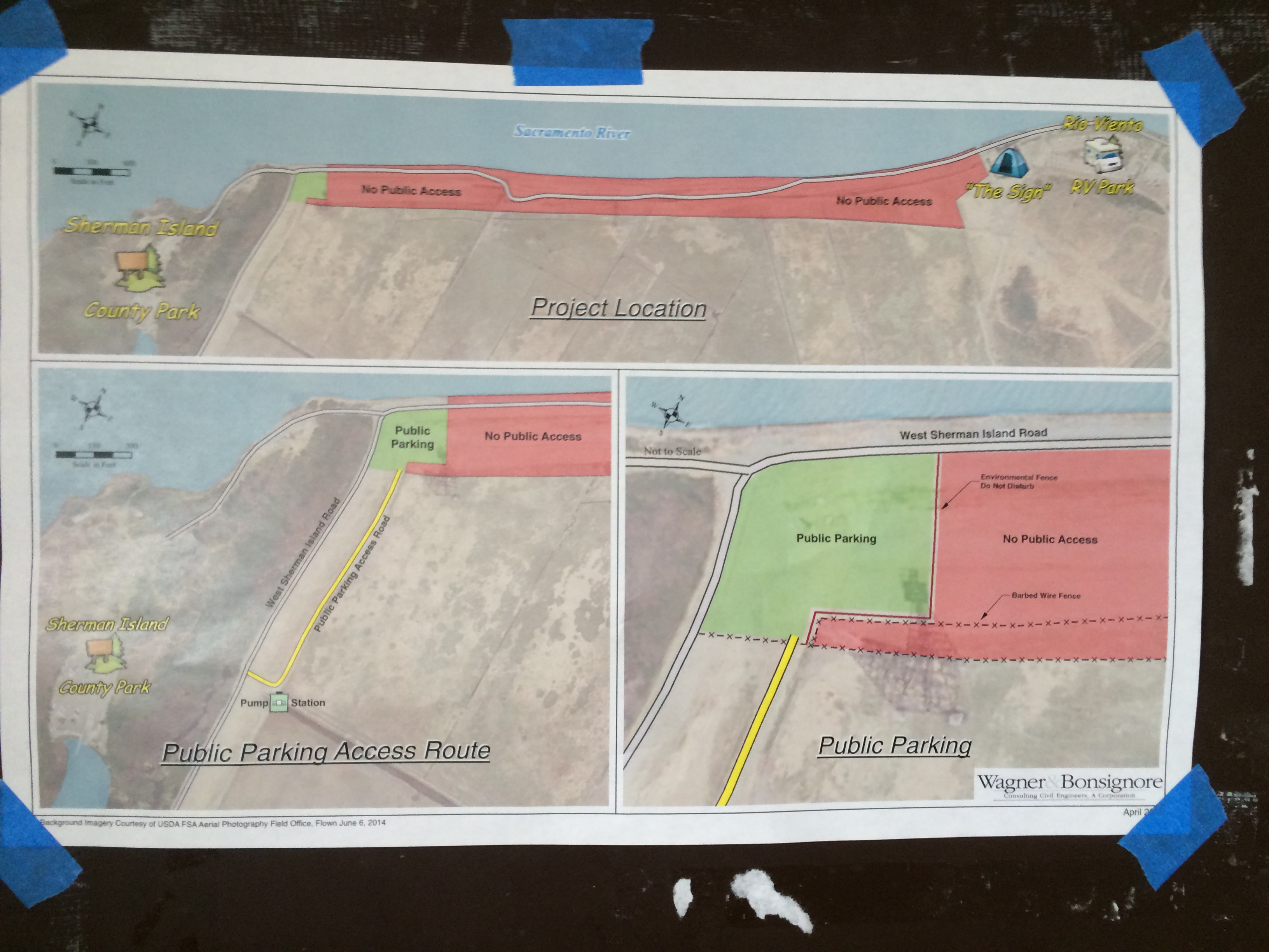
Upon review of the Initial Study, it is clear to SFBA and its constituency that the World-Class Recreational Uses of windsurfing and kiteboarding adjacent to and within your proposed project area would be potentially restricted and/or significantly impacted by your proposed project. Section 3.15.1 of the Initial Study (Environmental Setting: pg 3-77) acknowledges that public access and recreation on the navigable waters are protected under the Public Trust, and that windsurfing and kiteboarding do occur there. It also acknowledges that the project
. will only temporarily (during construction) result in restricted access within the project site for recreation. Because our members use the levee and road within the proposed project area for parking and for access to and from the water, we find it very difficult to conclude that there is No Impact when indeed, two years of prohibited recreational use is a significant impact and it will indeed overwhelm the modest county park immediately adjacent to the project.
The initial study is clearly inadequate in that it functionally ignores a recreational use that has been occurring at the site for over 30 years. By not including the existing use at the site, the document failed to analyze the impacts of the project, and determine whether or not mitigation measures or alternatives would reduce those impacts to a level of insignificance. Since the project would close parts of the levee road that are used for parking and launching permanently, and since the construction staging areas identified in Figure 2 would displace additional parking areas, it is clear that the project would directly interfere with parking and access to the water.
These areas are heavily used during the summer, and the loss of those areas would decrease the capacity of this site, one of the most important in the San Francisco Bay area. This clearly constitutes substantial adverse impacts on human beings, making it impossible to issue a negative declaration unless those impacts are mitigated to a point of insignificance. We have discussed the matter with you and with Ms. Delia Girjal, the person coordinating real estate acquisition for the project, and we believe that it is possible that mitigation measures can be developed that would allow the project to go forward without preparing an EIR. However, in failing to identify the existing use, the current initial study is fatally flawed.
RECREATION AND CEQA
For a number of years, an appendix in the CEQA guidelines indicated that adverse impacts to recreation were presumed to constitute significant impacts. We understand that the guidelines have been changed, and that the IS uses the current checklist. However, changing the guidelines does not mean that recreational impacts can be ignored, it simply means that adverse impacts on recreation are no longer presumed to be significant. Nor does the revision of the CEQA checklist allow such a perfunctory analysis as contained in the current document. Local sailors noticed consultants for DWR performing preliminary soil work for the project last summerwhen windsurfers and kiteboarders were present at the site and in the river adjacent to the site. To ignore those impacts in preparing an initial studywhile devoting dozens of pages to biological impactshas left the DWR with a fatally flawed document, and an erroneous conclusion on recreational impacts.
Proper CEQA analysis consists of establishing a baseline of existing resources that might be affected by any project. In this case, the baseline should have identified all of the areas used for parking by those seeking access, as well as all of the launch sites. An inventory of those parking areas, and the number of spaces within them, would have allowed numerical analysis of the projects impacts on those resources. Similar analysis should have established the pattern of launching from the sites along the levee that could be affected by the project. Currently, the area identified on Figure 2 as Primary Staging & Spoil Site B, and the levee road are used for parking. A full list of the recreational access sites can readily be found here: http://rvwa-siko.com/sites/
THRESHOLDS OF SIGNIFICANCE
It is incumbent on lead agencies to determine what public policies set guidelines for protection of resources, and to use those policies in establishing thresholds of significance that allow the impacts of a project to be weighed against those policies to determine whether or not they are substantial.
In California, the legislature, in passing AB 1296, the San Francisco Bay Area Water Trail Act, recognized the extraordinary value of recreational access to San Francisco Bay. Under that Act, Public Resources Code Section 66690 (b) provides:
(b) Water-oriented recreational uses of the San Francisco Bay,
including kayaking, canoeing, sailboarding, sculling, rowing, car-top
sailing, and the like, are of great benefit to the public welfare of the San
Francisco Bay Area. With loss of public open space, the public
increasingly looks to the bay, the regions largest open space, for
recreational opportunities. Water-oriented recreational uses are an integral
element of the recreational opportunities that span the San Francisco Bay
Area and add to the community vitality and quality of life that the citizens
of the region enjoy
Senator Torlakson followed this effort up with a bill in 2006, SB 1556, which directed the Delta Protection Commission to expand this concept to the Delta. The Vision for this effort can be found on their website, and includes clear support for access to the water:
The Delta Trail will be a interconnected regional network of land and water trails
The network will support recreation
http://www.delta.ca.gov/res/docs/trail/ ... 3-2010.pdf
Both of these measures implement the larger policies established in the State Constitution which give access to the waters of the state Constitutional standing.
No
corporation
possessing the frontage
. of a
bay
in this State, shall be permitted to exclude the right of way to such water whenever it is required for any public purpose, nor to destroy or obstruct the free navigation of such water (emphasis added)
While it may be argued that the waters offshore of Sherman Island are not a bay, there is no question that the state has established policies that protect and encourage access to those waters. To overlook the use, in light of these policies, is folly.
The existing parking areas, where construction staging is proposed, and where closure and fencing of the levee road are proposed, are needed to accommodate existing use. Parking within the Regional Park is often completely occupied, leaving these areas as the only possible parking areas for sailors, who come from throughout the Bay area and parts of the Central Valley, to park. As such, elimination of these parking areas will directly and substantially reduce the carrying capacity of this area, and will increase burdens on the County park. The IS blithely states, Improvements to the county road will require a county approved detour but will not result in loss of access. However, the conclusion in the IS that the project would have no impact on existing regional parks or other recreational facilities is factually wrong.
SAFETY
Permanent closure and fencing of the section of the levee road now used for parking and access to the water is proposed. This will not only eliminate parking that is needed to support existing recreation, it will decrease safety for users. Currently, the levee road in question is a fail-safe point of egress for sailors who may be caught in a flood tide, or be subject to a dramatic change in wind velocity. It allows them to swim to shore with their equipment and walk back to their parking area or the County park. This form of egress is critical to recreational safetyand not discussed in the document.
MITIGATION MEETING
We would like to meet directly with you and your staff to address appropriate mitigation measures which can be developed that would allow the project to go ahead without preparation of an EIR or relocation of the fish facilities. That meeting should be held jointly with our sister organizations, the Rio Vista Windsurfing Association and Sherman Island Kiteboarding Organization. Mitigation should include full replacement, in kind, of all parking and launch areas.
SFBA looks forward to your response, and we stand-by to meet with you as soon as practicable.
Sincerely,
Jim McGrath, Vice President
San Francisco Boardsailing Association
macmcgrath@comcast.net
(510) 848-8071
Cc: President@sfba.org
Directors@sfba.org
| Description: |
|
| Filesize: |
1.46 MB |
| Viewed: |
16751 Time(s) |
|
Last edited by Riptide on Wed May 04, 2016 10:24 am; edited 1 time in total |
|
| Back to top |
|
 |
Riptide
Joined: 15 Jan 2011
Posts: 411
|
|
| Back to top |
|
|
airwave
Joined: 29 Jun 2000
Posts: 386
|
| Posted: Wed May 04, 2016 12:46 pm Post subject: |
|
|
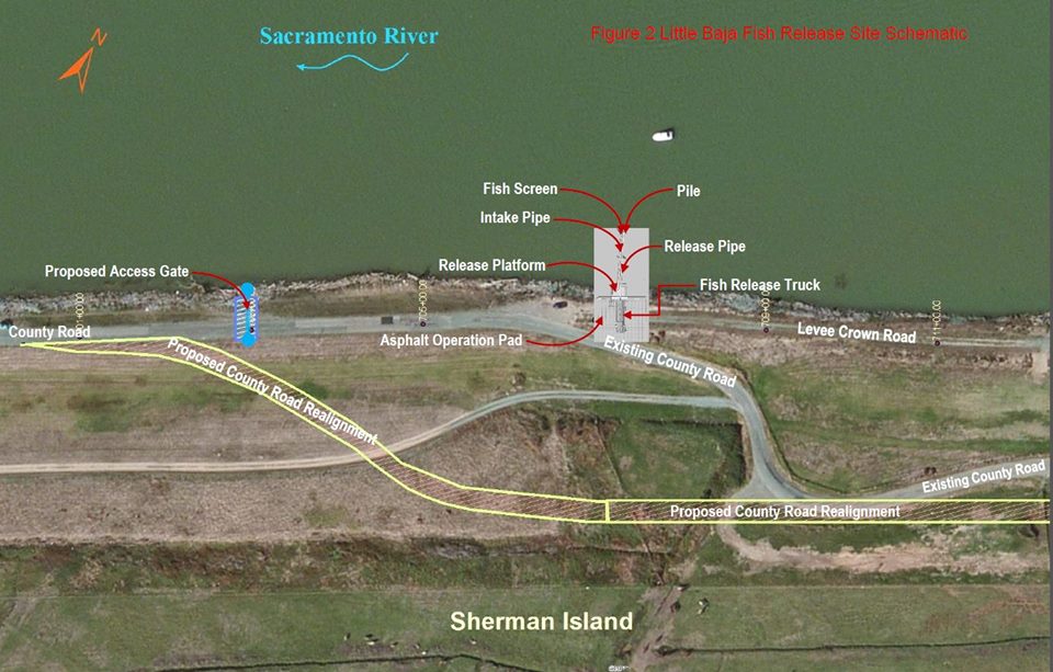
Page 13 of the RVWA-SIKO presents a recommended levee configuration for a 15' wide concrete launch.
This recommendation needs to be reconsidered.
This is similar to the launch that was added in Pittsburg on the jetty two years ago. It became obvious from the start the the slope of the concrete launch was unsafe and for all intents and purposes not usable. Changes were made by bolting in wooden steps last season. But even that solution is poor, especially for windsurfing. Though it is reasonable to bob your way up or down a steep slope with a kite pulling from overhead it is all but impossible to carry a windsurf board and sail up a slope that has such a steep angle. For that matter it is a poor design for kiting as well. Entering and exiting with a kite, windsurf rig, or kayak will be dangerous as designed.
Either the angle into the water needs to be reduced or wide steps need to be formed.
|
|
| Back to top |
|
|
Riptide
Joined: 15 Jan 2011
Posts: 411
|
| Posted: Wed May 04, 2016 1:34 pm Post subject: |
|
|
| airwave wrote: | Page 13 of the RVWA-SIKO presents a recommended levee configuration for a 15' wide concrete launch.
This recommendation needs to be reconsidered.
This is similar to the launch that was added in Pittsburg on the jetty two years ago. It became obvious from the start the the slope of the concrete launch was unsafe and for all intents and purposes not usable. Changes were made by bolting in wooden steps last season. But even that solution is poor, especially for windsurfing. Though it is reasonable to bob your way up or down a steep slope with a kite pulling from overhead it is all but impossible to carry a windsurf board and sail up a slope that has such a steep angle. For that matter it is a poor design for kiting as well. Entering ad exiting with a kite, windsurf rig, or kayak will be dangerous as designed.
Either the angle into the water needs to be reduced or wide steps need to be formed. |
These letters were written two years ago, where were you then. I do not know the current status or final plan other than that construction has started.
|
|
| Back to top |
|
|
jp5
Joined: 19 May 1998
Posts: 3394
Location: OnUr6
|
| Posted: Wed May 04, 2016 2:55 pm Post subject: |
|
|
| The levee road will be closed between the sign and the access?
|
|
| Back to top |
|
|
Riptide
Joined: 15 Jan 2011
Posts: 411
|
| Posted: Wed May 04, 2016 3:39 pm Post subject: |
|
|
| jpbassman wrote: | | The levee road will be closed between the sign and the access? |
No, diversion road or new road is being built.
|
|
| Back to top |
|
|
jp5
Joined: 19 May 1998
Posts: 3394
Location: OnUr6
|
| Posted: Wed May 04, 2016 5:24 pm Post subject: |
|
|
| Between the lane closures on 160 and now this you locals are going to have a tough time getting quickie before/after work sessions!
|
|
| Back to top |
|
|
beallmd
Joined: 10 May 1998
Posts: 1154
|
| Posted: Wed May 04, 2016 5:31 pm Post subject: Access |
|
|
| Sailed the Access fairly recently. Road was open for usual Little Baja and Access but a fence was up short of the end at the Access. Now I see it will be the opposite, that is you'll use the new road and drive in at the old Marina road and be able to use the Access end. It's a little small and would be a problem with the ABK camp otherwise should suffice. The question is will we be able to park farther south a long the road into the Access when crowded? Very pleased that the Access will remain open, mega cudo's for that! Esp given the wind being often better at the park and Access.
|
|
| Back to top |
|
|
Riptide
Joined: 15 Jan 2011
Posts: 411
|
| Posted: Wed May 04, 2016 7:48 pm Post subject: |
|
|
check it
| Description: |
|
| Filesize: |
108.6 KB |
| Viewed: |
16539 Time(s) |
|
|
|
| Back to top |
|
|
airwave
Joined: 29 Jun 2000
Posts: 386
|
| Posted: Thu May 05, 2016 10:28 am Post subject: |
|
|
Riptide,
I was sailing and did not know that there was an organization called SIKO working on the matter. I'm glad that there is. And after seeing and experiencing the problem at Pittsburg it seems like it would be worth revisiting the recommended solution.
I doubt that my suggestion of flattening the angle is possible, either because of issues with moving the levee farther out or making it wider. Both of which would be a pretty big deal.
But, changing from a sloped grade to a sloped graded made with forms for flat steps would be much easier to achieve though a bit more work. Steps would need to be wide enough to accommodate standing on with both feet, say 2 - 3 feet wide each.
So, who would a contact person be for communicating this and finding out what the plan and schedule is?
|
|
| Back to top |
|
|
|
|
You cannot post new topics in this forum
You cannot reply to topics in this forum
You cannot edit your posts in this forum
You cannot delete your posts in this forum
You cannot vote in polls in this forum
You can attach files in this forum
You can download files in this forum
|
|
|

