| View previous topic :: View next topic |
| Author |
Message |
windfind
Joined: 18 Mar 1997
Posts: 1905
|
 Posted: Tue Jun 28, 2022 12:28 pm Post subject: Blog: Meet Mr. upper trough & winds out East Posted: Tue Jun 28, 2022 12:28 pm Post subject: Blog: Meet Mr. upper trough & winds out East |
 |
|
Hi Gang,
jgda recently posted on the forums:
"I don’t really care about short waves, and blocking fronts etc. I just want to know if I should make the drive or plan something else."
I understand that reasoning. Frankly, even as a meteorologist, when I am in a rush and really want to sail I don't always read forecast text. I don't even read the table wind numbers.
I just look at the colors in the tables. RED means go. At least after checking the sensors to see if they are ramping up as forecast.
But often there is a simple advantage to reading the forecast text. There is no way a meteorologist is going to have the local knowledge that you have for your favorite sites.
That means you can learn to take the jargon in the forecast text and use it fine-tune your OWN forecast for your OWN sites that is better than any model or met.
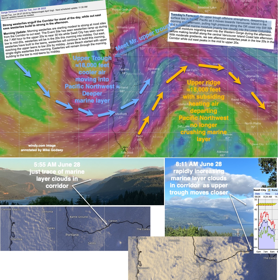
So for example when the forecast text, like today, talks about an approaching upper trough and deepening marine layer. I read that I know that the Hatch will probably have strong crappy early winds and Dougs may be a bit better if the clouds are not overhead.
But since an upper trough typically has SW to WSW wind that many impact the surface winds I start thinking about sites that like that direction like The Wall and Roos.
Then I look at the satellite imagery. Are there waves in the marine layer clouds coming from the WSW? (see image below) If so The Wall and Roos are more promising.
But since I know that in the last decade we have had more WNW surface wind that makes those sites poor I check all the PD sensors out east that are on high flat terrain. If they are mostly WSW then I hit the road. If they are mostly W to WNW I pass or go to Rufus which likes more W. https://wx.iwindsurf.com/map#45.686,-121.129,9,1
Give the jargon a try jgda
This blog will introduce you to the big wind maker for winds out east:
https://blog.weatherflow.com/west-coast-wind-blog-meet-mr-upper-trough/
Mike Godsey
Weatherflow
| Description: |
|
| Filesize: |
394.36 KB |
| Viewed: |
11406 Time(s) |
|
|
|
| Back to top |
|
 |
boggsman1
Joined: 24 Jun 2002
Posts: 9126
Location: at a computer
|
| Posted: Tue Jun 28, 2022 3:09 pm Post subject: |
|
|
| Mike...take a look at the forecast for last Thursday. Nothing resembling the best morning of the season at the Hatchery.
|
|
| Back to top |
|
|
windfind
Joined: 18 Mar 1997
Posts: 1905
|
| Posted: Tue Jun 28, 2022 3:37 pm Post subject: |
|
|
| Only Temperatures can be forecast with any accuracy that far out. Beyond 3 days any wind forecast for a specific site is very very iffy.
|
|
| Back to top |
|
|
isobars
Joined: 12 Dec 1999
Posts: 20936
|
| Posted: Wed Jun 29, 2022 2:22 pm Post subject: Re: Blog: Meet Mr. upper trough & winds out East |
|
|
| windfind wrote: |
1. I just look at the colors in the tables. RED means go....
2. There is no way a meteorologist is going to have the local knowledge that you have for your favorite sites. |
1. I look first for the dreaded WNW direction out east. Given that, I don't care whether the numbers or colors are.
2. I thought that's what we're paying Weatherflow to do. They often do, as indicated by much-appreciated comments amounting to "The Wall and Roosevelt will suck today, as all the wind will be on the Oregon side". Tuesday was a classic example, with a Roosevelt dead zone often 500 yards wide. Foils were getting snared in milfoil from shore to mid-river, and WSers had to slog halfway across and gamble on sail sizes to boot. A lot of work was expended by those who braved it, and several heavy wind heavy hitters mostly watched from shore after they got burned and/or watched others get burned by highly varying wind strengths and directions even on the far side.
|
|
| Back to top |
|
|
cgoudie1

Joined: 10 Apr 2006
Posts: 2599
Location: Killer Sturgeon Cove
|
| Posted: Wed Jun 29, 2022 6:42 pm Post subject: Re: Blog: Meet Mr. upper trough & winds out East |
|
|
Hey Mike, you already know all this but..........
Sure we pay weatherflow for that, but that doesn't mean you shouldn't take
your own recommendations at your local haunt. Back when I sailed at the Event Site(25 years ago). We
were sitting around watching some pretty full on 4.7, and a guy pulled up looked
at the water and started rigging a 6.2. I mentioned it looked a lot windier
than that, but he'd see the forecast (or maybe heard it on his pager or
Bart's best bet on the radio)) and knew what to rig. He did
survive the ride in and out, but then down rigged.
In Utah, I often forecast a SW 8M sail wind at Deer Creek, even when the
upper atmosphere is northerly. I don't always get it, but local knowledge
of the thermal really helps. IW is just one resource on your way to a
premium day on the water.
-Craig
quote="isobars"] | windfind wrote: |
1. I just look at the colors in the tables. RED means go....
2. There is no way a meteorologist is going to have the local knowledge that you have for your favorite sites. |
1. I look first for the dreaded WNW direction out east. Given that, I don't care whether the numbers or colors are.
2. I thought that's what we're paying Weatherflow to do. They often do, as indicated by much-appreciated comments amounting to "The Wall and Roosevelt will suck today, as all the wind will be on the Oregon side". Tuesday was a classic example, with a Roosevelt dead zone often 500 yards wide. Foils were getting snared in milfoil from shore to mid-river, and WSers had to slog halfway across and gamble on sail sizes to boot. A lot of work was expended by those who braved it, and several heavy wind heavy hitters mostly watched from shore after they got burned and/or watched others get burned by highly varying wind strengths and directions even on the far side.[/quote]
|
|
| Back to top |
|
|
isobars
Joined: 12 Dec 1999
Posts: 20936
|
| Posted: Wed Jun 29, 2022 7:37 pm Post subject: Re: Blog: Meet Mr. upper trough & winds out East |
|
|
Yes, but it is the only one for which I pay significant dollars in the hopes of fairly reliable forecasts despite the local topography. Many sailors plan trips from hundreds of miles away based on forecasts, (what other choice do they have?), and many of them rely heavily, sometimes even exclusively, on iW forecasts.
I keep my RV loaded for immediate departure on virtually no notice, study half a dozen independent forecasts, draw my own conclusions, watch the evolving wind real time, and when it tops 20 mph and looks likely to increase from there, I turn the key. The biggest, most consistent three factors making that a very hit and miss proposition are the changes in Gorge wind patterns Godsey explained, the fact that none of my sources consistently beats the others, and my medically mandated cherry picking*.
* In response to his significant other's "What should I rig?" in Tuesday's mess of wildly varying wind speed and direction, reportedly worst-ever river-wide weeds, and 500-yards wind shadow, a guy snapped, "Just rig something and get out there".
Can you spell, "Not tonight, honey"?
Tuesday was supposed to be a WSW day out east, good for Roosevelt. If Weatherflow can't install a sensor on the Corps-owned, fully wind-exposed, well-located Roosevelt east jetty, I guess I need to start studying the effects of those area-wide flatland wind directions Mike G mentioned in the hopes they are informative for the riverbed wind.
Hey, Mike ... how about some insight into the surrounding sites indicative of the riverbed winds out east?
I very often see folks rigging 3.x sails at Roosevelt based on early morning sun glints off the water. I don't suggest sails sizes to others, so I may say something like "It's blowing 16 out there .. not enough for my 6.2."
| cgoudie1 wrote: | IW is just one resource on your way to a
premium day on the water. |
|
|
| Back to top |
|
|
victor7468
Joined: 25 Apr 2022
Posts: 7
|
| Posted: Thu Jun 30, 2022 11:47 am Post subject: victortheinflictor.com |
|
|
| Just go to victortheinflictor.com I've been doing that accurately for 30 yrs here. I have that local knowledge, always give me a look to compare, I make my own models, they work. VTI
|
|
| Back to top |
|
|
jgda
Joined: 19 Jul 1999
Posts: 133
|
| Posted: Thu Jun 30, 2022 6:09 pm Post subject: respectfully disagree, we pay iwindsurf to interpret for us |
|
|
Mike,
Thanks for the response, but isn’t the meteorologist at iwindsurf for the gorge supposed to have local knowledge and importantly interpret the weather for us? I can read up a bit on weather patterns etc., but I pay iwindurf to do this for me.
I think you may over-estimate what end-users actually know who have been sailing in the gorge for decades. Sure, I can look at wind direction, pressure, clouds on a given day, but as you know, this is dynamic, and what I want to know the day before is whether there is a good chance for solid wind, and the day of, around noon, whether it will persist, improve or worsen.
I have always enjoyed your forecasts, but I have to say this year, we seem to have a new meteorologist that is leaving me and a lot of others scratching our head. More often than not, predicted wind speeds have been way less than what we have been encountering on those iffy days (the ones we really care about. Yesterday was an example. The 11:30 update did not acknowledge that the wind was way stronger than predicted even though all one had to do was look at the wind speeds. We are looking less at iwindsurf and more to Temira (nobody is perfect, but she is way more in the ballpark, light on jargon and heavy on estimated wind at different locations).
I guess I will continue to pay for iwindsurf so i can see actual wind speeds, but I have mostly given up on the forecasts.
|
|
| Back to top |
|
|
windfind
Joined: 18 Mar 1997
Posts: 1905
|
| Posted: Fri Jul 01, 2022 11:58 am Post subject: |
|
|
Jgda said: "Sure, I can look at wind direction, pressure, clouds on a given day, but as you know, this is dynamic, and what I want to know the day before is whether there is a good chance for solid wind, and the day of, around noon, whether it will persist, improve or worsen."
Hi jgda,
Thanks for taking the time for a thoughtful response.
I think meteorologists use the term "local knowledge" very differently than you.
Local knowledge to us means things you can see, long after a forecast is issued, from your house or on your drive or at the beach. These are things that models or meteorologists could never see unless they had an office that spanned the entire Gorge.
So Local knowledge is things like tree movement, wind patterns on the water, cloud direction on your drive. Even which way the wind is coming in your neighborhood.
If you are wind smart you use your "local knowledge" to fine-tune a forecast in real-time since weather is dynamic and always changes.
Here are some examples of my personal "local knowledge":
1. My house faces due west looking down the Gorge and on a promising Hatch day the wind hits my house from that direction. But my driveway faces WNW and if the wind is coming down my driveway the Hatch will probably be crummy
2. If I am standing at The Wall facing the water and I feel gusts from behind me and white caps mostly on the Wall side I know that both The Wall sensor reading and the forecast for low 30's winds were WRONG for my WA side sailing so I head to Rufus.
3. I always stop at pullouts on Hwy 14 and at Stonehedge to look at the wind turbines, wheat fields and the wind and swell pattern on the water before making a final decision where to go. Are the turbines on the highest ridges pointing WNW or W or WSW? Do the wheat fields show uneven wind patterns from the WNW? I do the same on the drive to Roos.
4. etc.
We hire very qualified meteorologists who have worked in NWS, industry and the military. During the America's Cup the winning team, owned by one of the world's richest men hired us for the forecasting. BUT training a new Gorge forecaster to forecast on such a micro scale is difficult and, like learning to jibe, it takes time. So, when you see a new name over a forecast lower your expectations for a while and use all available forecasts.
Beyond accuracy, the other issue that new forecasters have to learn to take very complex weather factors and reduce them into sentences that make sense to everyone. We get complaints ranging from "Your forecasts are too dumbed down to "it is gibberish to me" All I can say is that I am always pushing to have almost every sentence in forecasts relate directly to winds.
And when the forecast is bad and/or the winds suck there are always videos from before our winds changed: https://windnotes.smugmug.com
Mike
| Description: |
|
| Filesize: |
735.87 KB |
| Viewed: |
11120 Time(s) |
|
|
|
| Back to top |
|
|
isobars
Joined: 12 Dec 1999
Posts: 20936
|
| Posted: Fri Jul 01, 2022 5:57 pm Post subject: |
|
|
| On his website, Mike G wrote: | | [I] spent 18 months, 7 days a week, 10 hours per day building [my Gorge house] ... I even skipped a season windsurfing! |
That's impressive, and I can't comprehend the task and your results. It took me a very similar effort (I didn't stop WSing) and most of two whole years just to convert a new, raw Ford cargo van into a fully equipped, legally registered, tax deductible motor home.
I'll bet your home is worth more than the $3,500 I got for mine 14 years later, but then it doesn't follow you from Pistol River to Roosevelt to Florida. Tradeoffs.
|
|
| Back to top |
|
|
|
|
You cannot post new topics in this forum
You cannot reply to topics in this forum
You cannot edit your posts in this forum
You cannot delete your posts in this forum
You cannot vote in polls in this forum
You can attach files in this forum
You can download files in this forum
|
|
|

