| View previous topic :: View next topic |
| Author |
Message |
windfind
Joined: 18 Mar 1997
Posts: 1905
|
 Posted: Wed May 25, 2022 11:10 am Post subject: Marine surge VIDEO! Posted: Wed May 25, 2022 11:10 am Post subject: Marine surge VIDEO! |
 |
|
Hi Gang!
Kerry is forecasting today but I am following the trajectory of the marine surge zooming up the coast from Southern California.
In past decades foggy marine surges brought the end to mid to late summer heatwaves and made the north tower to Sherman Island corridor rip. But this last decade increasing eddies near the Golden Gate have been the norm with marine surges becoming rare.
If you are new to the Bay Area where is a video of a Marine Surge: https://windnotes.smugmug.com/Videos-WindsurfKite/1-Gorge-Videos/i-w8Gt9Lv/A
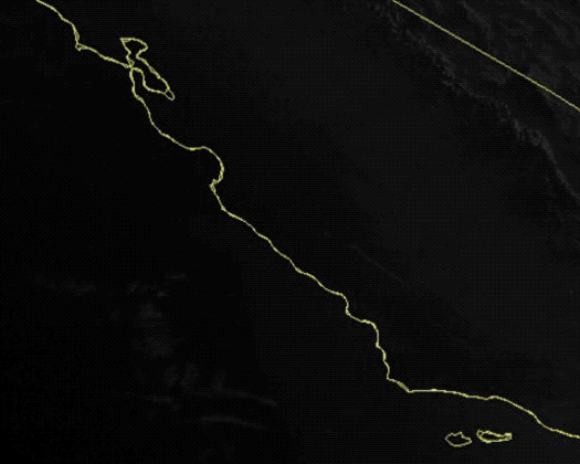
Already the fog from this marine surge is near Santa Cruz and its southerly winds have passed Santa Cruz. As you can see in my satellite image below there is a strong pressure gradient to the N. coast which is driving the surge. Plus there is the Sacramento to Redding area which favors WSW winds inside the Bay.
Normally I would be certain of the marine surge arriving in the next few hours. But today we have strong NORTH winds just aloft with Mt. Diablo seeing N 35G43. These winds will fight the marine surge but since the surge is made of heavy dense wind there is a good chance it will keep on flowing our way.
Watch the Half Moon Bay, Ocean Beach and Golden Gate cams!
Mike Godsey
| Description: |
|
| Filesize: |
629.99 KB |
| Viewed: |
3570 Time(s) |

|
Last edited by windfind on Wed May 25, 2022 7:41 pm; edited 1 time in total |
|
| Back to top |
|
 |
mac
Joined: 07 Mar 1999
Posts: 17775
Location: Berkeley, California
|
| Posted: Wed May 25, 2022 4:50 pm Post subject: |
|
|
| Sick windy, way more than predicted. At the Berkeley reef—holes under 10, gusts over 40. All of that with high clouds suggests a bit of a frontal push going beyond our usual 30 in a marine push.
|
|
| Back to top |
|
|
dllee
Joined: 03 Jul 2009
Posts: 5329
Location: East Bay
|
| Posted: Wed May 25, 2022 6:37 pm Post subject: |
|
|
| Yup, windy and holey, shifty and mysterious...
|
|
| Back to top |
|
|
windfind
Joined: 18 Mar 1997
Posts: 1905
|
| Posted: Wed May 25, 2022 7:32 pm Post subject: |
|
|
Hi Mac & Dllee,
The nearest front is about 1000 miles away and heading away from us. The high very high thin clouds are just the edge of a cloud mass passing over the Pacific Northwest. So neither had anything to do with our "holey, shifty and mysterious...winds"
Benefiting from retrospective knowledge... I would have forecast stronger winds today since there were already decent SW winds in the AM due to one pressure gradient to Redding. Check it out in the graphic above. Then in the PM the second pressure gradient you see over the coast in the graphic would have added the marine surge winds.
But why were the winds so crazy UP AND DOWN?
Mt. Diablo NNE winds 39G46 in the morning then faded but those strong winds continued nearby.
Now, consider what it means to have NNE wind aloft fighting with SSW marine surge surface winds. That means you have 2 very strong wind masses in close vertical proximity going in OPPOSITE directions.
To me it means a recipe for were a recipe for "holey, shifty and mysterious...winds"
Here is image of the entire marine surge fromdawn to 5 PM today's.
And then a video from Mt. Tam of the marine layer hitting the Golden Gate and zooming past Pt. Isabel.
Mike Godsey
IW/K
| Description: |
|
| Filesize: |
1.77 MB |
| Viewed: |
3452 Time(s) |
|
| Description: |
|
| Filesize: |
1.8 MB |
| Viewed: |
3457 Time(s) |
|
|
|
| Back to top |
|
|
|
|
You cannot post new topics in this forum
You cannot reply to topics in this forum
You cannot edit your posts in this forum
You cannot delete your posts in this forum
You cannot vote in polls in this forum
You can attach files in this forum
You can download files in this forum
|
|
|

